
Page 8 - DGO 2025
P. 8
3 4
S
L
F AL
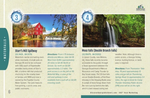
R Starr’s Mill Spillway Moss Falls (Double Branch Falls)
E
A T (33.3425, -84.5179) Directions: From I-75 between (32.95075, -84.51202) weather. Note: Although there is
W Waterfalls can be enchanting even Atlanta and Macon, take GA-16 In Upson County, near Molena, public access, a Georgia fishing
GA, these falls recently became
West from Griffin approximately
license, hunting license, or lands
when manmade. A small park on
Georgia 85 (not to be confused 20 miles to GA-85 North at accessible to the public through pass is required.
with I-85) south of Fayetteville Senoia. Go north on GA-85 a lease agreement between the
provides lovely views of Starr’s approximately 3.3 miles. The Georgia Department of Natural Directions: From Thomaston: Take
Mill, a turbine mill that produced park access is on the left at 115 Resources and Camp Thunder (a Hwy. 74 west approximately 12
electricity for the nearby town Waterfall Way; a view of the Boy Scout camp). The 20-foot falls miles and go left on Thundering
of Senoia until 1959 and now is mill and spillway is also are on Double Branch, a Flint River Springs Road. In approximately 2.4
owned by the Fayette County available from a pull-off on GA-85 tributary in the Dripping Rocks area. miles, the sign-in kiosk for Camp
Water System. The park features traveling south. A curtain of moss hangs down from Thunder Voluntary Public Access
free parking, a picnic area, and the rock outcrop behind the falls, (VPA) area will be on the right.
public restrooms. which is best viewed during wet
6 D i s c o v er Geor gi a O ut doors . c om • 3 6 5 ° To tal M ar k eti ng