
Page 8 - Discover Georgia Outdoors 2022
P. 8
3 3 Directions: Take US 23/441 north from 4 4 5 5
Tallulah Falls for three miles to the
Rabun Beach Recreation Area sign.
Turn left onto Old 441. Drive for 2.5 PHOTO BY KELLY L FROM PEXELS
miles and take a left on Lake Rabun
Road. Go one mile past the Recreation
Area. Turn left on Low Gap Road at
HIKES Bear Gap Road which forks to the WATERFALL
the Flat Creek Community sign. Follow
left. Continue for 1.5 miles to the sign
marking the trail on the right side
WATERFALL minute walk from the parking area on 4 Long Creek Falls 5 Hemlock Falls HIKES
of the road. The trail is about a five-
Bear Gap Road.
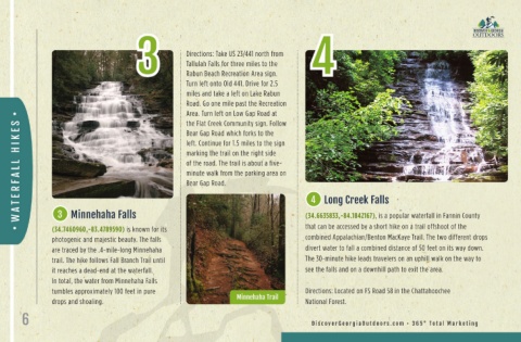
3 Minnehaha Falls
that can be accessed by a short hike on a trail offshoot of the
76 east for 11 miles. Turn left on GA
(34.7460960,-83.4789590) is known for its (34.6635833,-84.1842167), is a popular waterfall in Fannin County (34.8525170,-83.6109170). Hemlock Directions: From Clayton take Hwy
Falls is a breathtaking scenic area
photogenic and majestic beauty. The falls combined Appalachian/Benton MacKaye Trail. The two different drops that encompasses two waterfalls that 197 and continue for 3.7 miles to
are traced by the .4-mile-long Minnehaha divert water to fall a combined distance of 50 feet on its way down. cascade 15 feet in length in Moccasin the turnoff for the Hemlock Falls
trail. The hike follows Fall Branch Trail until The 30-minute hike leads travelers on an uphill walk on the way to Creek State Park. The trail is one of Trailhead. From the trailhead, follow
it reaches a dead-end at the waterfall. see the falls and on a downhill path to exit the area. Rabun County’s most scenic paths, the trail about one mile up the left
In total, the water from Minnehaha Falls and it traces Moccasin Creek upstream side of the creek and cross the creek
tumbles approximately 100 feet in pure Directions: Located on FS Road 58 in the Chattahoochee from Lake Burton until it ends with the on a wooden bridge shortly before
drops and shoaling. Minnehaha Trail National Forest. two waterfalls. reaching the falls. Hemlock Falls
6 DiscoverGeorgiaOutdoors.com • 365° Total Marketing DiscoverGeorgiaOutdoors.com • 365° Total Marketing 7